Agriculture is the backbone of Indian economy and the pivotal sector for ensuring food security. Timely
availability of information on agriculture is vital for taking informed decisions on food security issues. India is one of the few countries in the world that uses space technology and land-based observations for generating regular updates on crop production statistics and providing inputs to achieve sustainable agriculture.
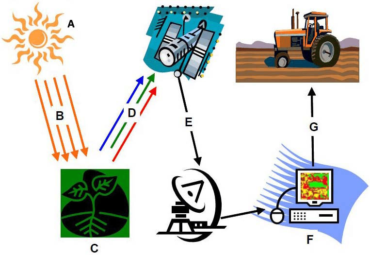
Satellite-based optical and radar imagery are used widely in monitoring agriculture. Radar imagery are especially used during monsoon season. Integrated use of geospatial tools with crop models and in-situ observation network enables timely crop production forecasts and drought assessment & monitoring.
Remote sensing is the acquisition of information about an object or phenomenon without making physical
contact with the object and thus in contrast to on-site observation. Remote sensing is used in numerous fields,including geography, land surveying and most Earth Science disciplines (for example, hydrology, ecology, oceanography, glaciology, geology); it also has military,intelligence, commercial, economic, planning, and humanitarian applications.
Geographical Information System (GIS) combines location data with both quantitative and qualitative
information about the location, allowing you to visualize, analyze, and report information through maps and charts.Using the technology, you can answer questions, conduct what-if scenarios, and visualize results. GIS is identified as a system used to manage infrastructure assets, natural resources and any objects as per requirement. It is easier to analyze and manage facility and asset data stored in GIS, making design, construction, and maintenance more efficient and profitable.
Leave A Comment